Impact of Temperature and Rainfall on Crocodile Populations in Northern Territory Rivers ENV4012
- Subject Code :
ENV4012
crocodile Management Analysis Post ban Effects through Temperature and Rainfall on Crocodylus Porous Populations within Northern Territory Australia
Contents
1.1Aim
1.2Hypothesis:
1.3Materials
1.4Methods
1.5Results
Abstract
Crocodlyus porous, or through its common name of Estuarine saltwater crocodiles, was the testing subject in this observational study to determine crocodile population abundance through both temperature and rainfall. The data expands over 40 years. Over the years, crocodile management has changed from killing crocs to prohibiting certain rivers so that the crocodile population can rise again, which will be how the data is presented and compared to the rivers where crocodile removal occurs and where it does not based on the temperature and rainfall variables. The data will be collected through the Government NT Parks and Wildlife Department, and with the raw data of crocodile presence, After-Before, Control-Impact, Mean Temp C and Annual Mean rainfall mm, Calculations will be made to calculate the data summary, box plots, geombar plots, and tables, further understanding the effects of temperature and rainfall on crocodile populations. The results showed that temperature had more impact on crocodile presence than rainfall, and undisturbed rivers always had a higher crocodile presence before and after the ban. This would indicate that swimming within the controlled areas is safer than those left alone. The conclusion is that the crocodile population has increased after the ban and is significantly higher within areas undisturbed.
Introduction
The Northern Territory (NT) continues to debate annually whether the Crocodile Management Act needs to be revised since its alteration in 1971, which was dedicated to the protection of crocodiles, making it possible to rejuvenate population numbers and stop crocodile culling, as the crocodilians of the NT were near extinction. With support from croc farmers, the conservationist International Union for Conservation of Nature (IUCN) called for this legislation, as numbers were below carrying capacity. With excessive demand in Europe after World War II in 1946, crocodile skin were in great demand, with an estimated total of 113,000 wild saltwater crocodile skins exported from the NT; 87,000 were exported from 1946 until 1958, and 26,000 from 1959 until 1971, once dense crocodile habitats like Adelaide, Mary, Alligator Rivers, and Daly had been severely depleted. This altered the vegetation of the riverside, floodplains, billabongs, and swamps, which were crucial for crocodiles to build nests. These habitats had also been denuded by buffalo, causing more significant grazing pressure and creating saltwater intrusion.
https://online.cdu.edu.au/ultra/courses/_58311_1/outline/edit/document/_5086999_1?courseId=_58311_1&view=content
Reports suggest 21 remote rivers through Arnhem Land, where wetlands had been in better condition, as hunting was less intense due to high crocodile abundance. However, adult crocodiles were still scarce and wary.
Field reports started in 1971 have been conducted throughout the years, using various methods (spotlight counts, aerial counts, track surveys, and boat sightings) to locate remnant saltwater crocodile populations. (Messel et al., 1981; Webb et al., 1984; Webb et al., 2000).
The analysis of crocodiles recorded during the hunting was high. Saltwater crocodiles were historically abundant in tidal rivers and other coastal floodplain wetlands. During the period of intense hunting (194650), the commercial sizes on which they concentrated (69 ft; 23 m) were in high densities (612/km sighted in spotlight counts) in 15 rivers, modest densities (15/km) in 10 rivers, and reasonably scarce densities (<1>https://online.cdu.edu.au/ultra/courses/_58311_1/outline/edit/document/_5086999_1?courseId=_58311_1&view=content
Today, crocodile populations have succeeded in carrying capacity, and with crocodile farming being successful, farms are self-reliant and do not need to harvest from the wild anymore. The issue is that now that the population has become so great, crocodiles are becoming problematic, with more crocodile sightings, disruptions in public natural park swimming areas, and stations killing livestock.
To reduce the likelihood of crocodile attacks, the Parks and Wildlife Service of the Northern Territory operates a program to remove crocodiles from Darwin Harbour. Between 1999 and 2004, 926 C. porosus were captured, mostly in permanently set traps. Of the crocodiles captured, 62% were 1.5-2.5 m total length (TL), 12% were less than 1.5 m TL, and 2.5% were more significant than 3.5 m TL. Males comprised 74% of captures. Capture rates were highest in March, April, and May and monthly capture rates in the late-wet and build-up seasons increased throughout the study. The increase in crocodile capture problems suggests that future crocodile removal efforts must be increased to reduce the risk of crocodile attacks on humans in the Darwin area.
This begs the question: Should a cull happen again? However, it must be ensured that temperature and rainfall do not play a huge part in the crocodile population, which is irreversible.
https://www.publish.csiro.au/WR/WR06110_CO
Aim
This investigation aims to calculate the raw data of crocodile presence from rivers that are controlled and impacted before and after the ban based on the temperature and rainfall in Northern Australia
Hypothesis:
This study's hypothesis is it will be an alternative that crocodile presence will increase after the ban and with the increase of both temperature and rainfall.
Materials and methods
Materials
include the collected data from 1960 to 1971 and 1972 to 2020 on the Northern Territory rivers. Of this data, crocodile presence (1) was identified, and (0) was unidentified during the surveys. These were conducted within controlled ( C ) rivers monitored to remove crocodiles, whether culled before or relocated after the ban; the Impact areas are those where croc culls were prohibited, and removal today is not allowed. The mean temperature and rainfall for each river type were recorded during these surveys. (e.g., Fukuda et al. The data will be calculated through a software application called R Studio.
To understand crocodile management further, one needs to see how the crocodile altered act has benefited the crocodile population and if the temperature and rainfall contributed to the success it is today and used as a guide if crocodile culling were to happen again.
2008; Campbell et al., 2013; Fukuda & Saalfeld, 2014). Thus, evaluating whether these variables significantly affect their presence would be best.
Methods used for the data will be imported into a software application called R Studio. Make sure the data is imported and listed as a string of factors. To complete the tables and graphs featured in the results, the required downloadable packages need to be installed into the script with (ggplot2) that will be used to calculate the box plot and geombar plots, (bbmle) is used for the highest AICS and lowest AICS and Variance Inflation Factor, (mvabund) model validation,(car) Probability of B.ps Occurrence and (interactions) plot estimated effect.
While writing the scripts, ensure that the appropriate headings are used, as the data will not run the scripts properly.
Results
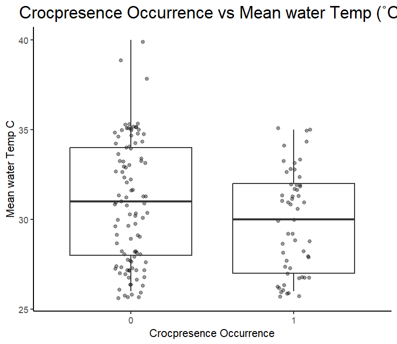
Graph 1 shows a higher count where no sightings were made, represented by the 0 box plot, than with actual crocodile sightings, represented by the 1 box plot. The IQR is higher for the no crocodile sightings compared to that where crocodile sightings did occur.
Summary of croc_data
|
Before_After |
Control_impact |
Mean_water_Temp_C |
Mean_annual_rainfall_mm |
|
A:82 B:73 |
C:62 I:93 |
Min. : 26.00 1st Qu.: 27.00 Median: 31.00 Mean: 30.46 3rd Qu.: 33.00 Max. : 40.00 |
Min. : 916 1st Qu.:1250 Median:1561 Mean:1522 3rd Qu.:1778 Max. :2102 |
Table 1 shows the basic principles of the raw data of Croc_data, with the counts of After and Before, Control, and Impact, within the Mean_ water_Temp_C and Mean_Annual_ rainfall_mm, showing the min, max, and INQ ranges.
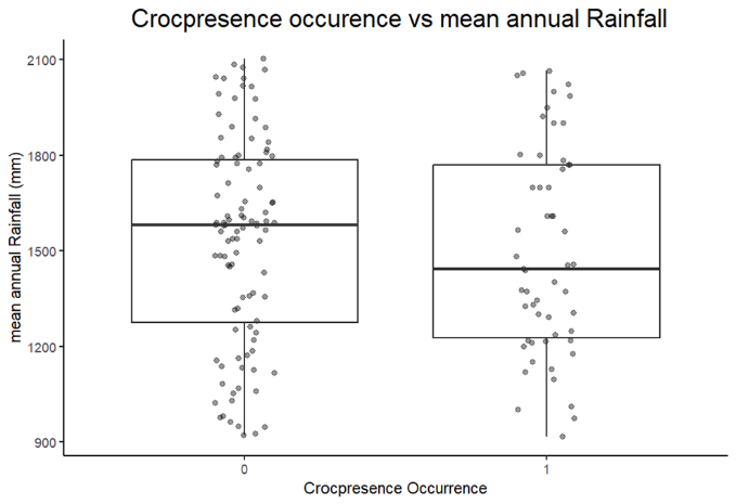
Graph 2 shows little variations between that of no crocodiles being sighted represented in box plot 0 compared to crocodile sighted represented in box 1, despite that more surveys were coming back with no crocodile sightings than actual sightings. This would change the mean within the IQR, which shows that the mean is lower for actual crocodile sightings.
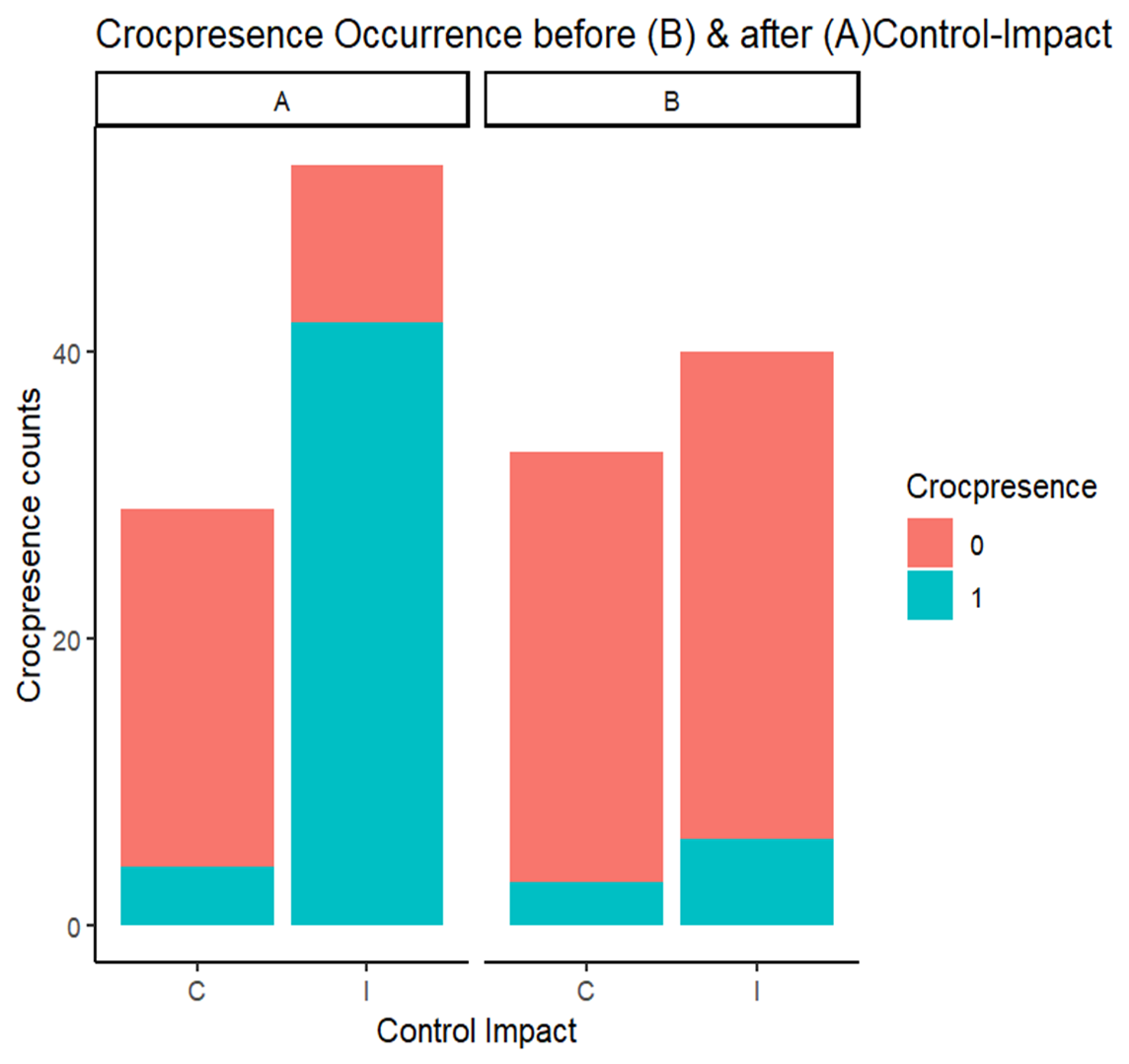
Graph 3 shows the relationship between crocodile presence, represented by crocopresence counts, and control and impact on rivers before and after the ban. The data shows that before the ban, both rivers were more negatively represented by 0 than after, with the control slightly more positively represented by 1; however, the impact was most affected by reaching the highest with over 40 crocopresence counts.
A model with the lowest AICc
|
Model |
AICc |
dAICc |
df |
weight |
|
m2 |
139.6 |
0 |
4 |
0.447 |
|
m3 |
140.9 |
1.3 |
5 |
0.234 |
|
m4 |
141.5 |
1.9 |
5 |
0.145 |
|
m5 |
142.7 |
3.2 |
6 |
0.92 |
|
m1 |
143.9 |
4.3 |
3 |
0.053 |
|
m0 |
203.6 |
64.1 |
1 |
<0> |
Table 2 shows the data model that is the most creditable to use within the modelling. The data shows that m2 is the most creditable model.
Variance Inflation Factor
|
Before_After |
Control_impact |
|
3.12714 |
1.727541 |
|
Before_After:Control_impact |
|
|
3.674908 |
|
Table 3 shows the variance inflation factor of model 2. The data represent each predictor's value under 4, which indicates that there are no collinearity issues.
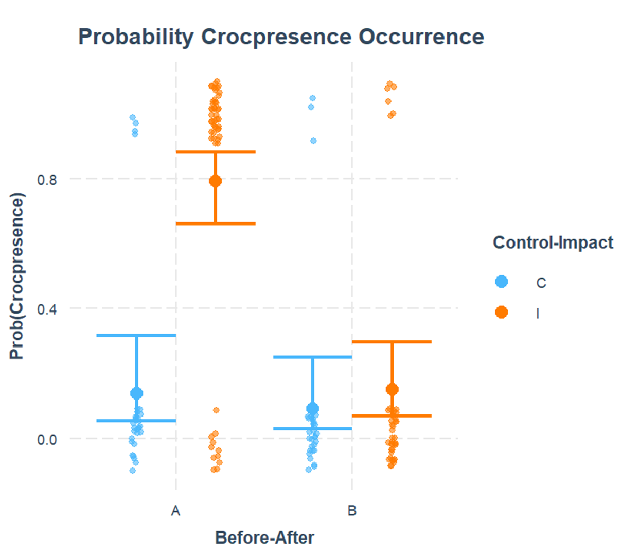
Graph 4 illustrates
Shows the relationship between the probability of crocodile sights represented as prob(copresence) compared to before and after the ban represented as Before-After
This data shows that the probability of sighting a crocodile will always be higher in the impact areas. Even though the mean for both control and impact was less than 50?ter the ban, it is seen that the control is still under a mean of 50%, unlike the impact, which has reached a mean of 80% .
Discussion
Results indicate several things that can be considered in crocodile management. Firstly, crocodile numbers have increased since it was banned; secondly, the impact rivers have shown the most significant improvement compared to controlled rivers. Comparing this to temperature and rainfall, it appeared that temperature had a more contributing effect on the crocodile population than rainfall, which will require further testing to help contribute to crocodile management in the Northern territory. The implications of this study would be the sampling errors, as the data was from an observation assessment. Errors could have included inaccurate readings from the gauges, whether electronic, thermidor or a rain gauge to indicate proper readings. The Crocs counts could have potentially been miscounted. How the data was counted, if one or even two persons were doing it, was not specified, and the locations where the crocodiles were spotted within controlled or impacted rivers were not specified.
Other studies
What can be implemented from the observations of other studies is the focus on the geographical location while doing the crocodile surveys. A more precise analysis of the location of each control and impact river could further decipher the annual temperature and rainfall within those areas as the sample size is too broad, placing trackers on several crocodiles, which was done within a non-tidal waterhole in Lakefield National Park in northern Queensland during the late dry/mid-wet season (200304). The following dry season (2004) could allow further observations into the location/time and temp/ rainfall, where a time series of data could be produced and show trends continuously through the years of tracking movements of temperature and rainfall. The study found that individual crocodiles occupy the most extensive home ranges, or river channel areas, during the late dry/mid-wet season (10.64 2.86 ha) compared to the dry season (3.20 1.02 ha). It was observed that males occupy more extensive home ranges (23.89 2.36 ha) than females (5.94 1.34 ha) in the late dry/mid-wet season. There were no apparent discrepancies in the home range between males and females during the dry season. During the late dry/mid-wet season, adult males were observed travelling long distances while females moved less. During the dry season, movement patterns were variable, with no apparent difference between the sexes.
Incorporating this type of surveying benefits far more significantly as it can also be calculated not within annual mean basses but within 24 hrs as they observed Crocodiles of both sexes were most active between 1500 and 1800 hours or until midnight. The individual home ranges overlapped extensively during the late dry/mid-wet season. It was fascinating to see the extent of the overlap of the home ranges of three adult males and the number of times they either passed or moved close to one another. This leads to another study incorporating crocodile nests and examining female and male behaviour during the buildup and months of rain within the Northern Territory. This is important as crocodiles need to incubate their nests between 30c 33 degrees for a successful birth rate.
A study on the oil palm in the Lower Kinabatangan region of Eastern Sabah. Drones, or unmanned aerial vehicles (UAVs), are used to find crocodile nests in fragmented landscapes. Flights using fuzzy overlay models found nests located primarily in areas indicated as suitable habitats. Nests displayed several similarities in habitat characteristics, which were used to refine the surveying sites' modelling. Using drones is more cost-effective than performing traditional nesting surveys; drones also allow for more extensive surveying, albeit with a limited number of flights. This approach has the potential for widespread applicability across a range of species and a variety of study designs. Five nests out of 29 potential locations were identified; all other potential nests, unaffected by flooding, were visually discounted on the ground. The approach, albeit in need of refinement, significantly improved the traditional techniques; for example, costly helicopter surveys entailing flying over large tracts of unsuitable habitat would still require a person on the ground checking[4].
Identifying five nests within a relatively small (6710 ha) area of the study site suggests that crocodile females actively select areas identified by the habitat suitability model as potential sites with open or semi-open canopy coverage, allowing for highly selective and highly predictive flight mission planning. The walking recces performed provided the necessary justification for using drones to identify potential nesting sites and crocodilian habitats. Although the distance walked was short (120 km), the transects' placement to encompass tributaries, ox-bow lakes, and other areas of permanent water sources indicated that dense forest canopy was not a crucial nesting habitat (Hypothesis 4). Identifying nests near oil palm plantations demonstrated that females could nest within medium to high human disturbance areas.
Nesting appears to be occurring at low densities, and whilst it is, at least to some extent, predictable, the presence of degraded, patchy secondary forests represented a challenge to successful and encompassing nesting surveys. Due to breaks in forest canopy coverage, secondary forest results in far larger expanses of open areas than would likely be present if the region retained its original primary forest landscape. As a result, refining search grids is more challenging in secondary forest ecosystems than in pristine primary forest habitats. Despite this reduction in canopy coverage, it is unlikely that all nests will be built in open areas, and did raise a question in regards to alternate heat sources as some crocodilians can use alternate heat sources, such as termite mounds, to keep their nests at the optimal temperatures.
As Webb et al. [3] determined, flooding is the primary threat toC. porosusnests, with ten potential nests submerged during the ground-verification period, and the river rose by more than 1 m overnight. Evidence shows that increasing global temperatures associated with global warming could double the frequency of El Nio events [27]. Unstable weather during nesting periods could lead to variability in the successes and failures of nesting seasons.
In carrying out this study, numerous UAV-related challenges were identified. While the replicability of transect observations is one of the significant benefits of the technology over traditional techniques, the vast disparity in the resolution of the images produced within the two surveys of 2014 creates concern. The variation could have committed potential nest locations and, conversely, produced low-resolution images, meaning that many nests also needed to be verified from the ground. A similar image resolution to that achieved during the 2013 surveys (56 cm per pixel) would have allowed for excluding a number of the 2014 'potential' nests. In addition, the number of nests in this study provided limited statistical power. Expanding the study range to provide a more extensive dataset allows more conclusions to be interpreted.
Whilst in terms of cost, drone technology is far cheaper than many traditional survey methodologies, the main barrier to its use by small independent research projects is the cost of image stitching (a cost of around GBP1 per hectare [total area surveyed 6710 ha]). The number of images produced during flights prohibited freeware image stitching software, allowing these data to be collected and utilised without image stitching, but detailed analysis of each specific image would take much longer. Additionally, placing any potential nest's location within the broader context of the landscape and assessing the hydrological relations would be far more challenging and require highly specified knowledge of the study region.C. porosus individuals in the are not group nesters. However, statistical predictability exists for nesting site locations regarding distance from water bodies, thus allowing search area refinement. Nests and any previously used nesting sites were located several hundred meters from each other. Nesting sites were found to be at medium disturbance levels, although the presence of nest sites close to plantations suggests that human disturbance is not necessarily a barrier to nesting. This suggests stable estuarine crocodile populations could endure even in moderate to high land-use conversion areas. A long-term monitoring programme is required to monitor the stability of the population in such areas.
https://www.mdpi.com/1424-8220/16/9/1527
While nest counts can be incorporated by looking into the egg clutches' temperature, which can reveal even more data that can be drawn from as the sex of the egg is determined by the temperature of the incubation. This is vital as when the temperature is from 28-30, all hatchlings within the nest are female, with 31c being half male and half female, 32c all being male, and a degree warm shifts the eggs back to all females. Ideally, the temperature within the nest should be 31c and never exceed 33 degrees or less than 30c as infertility and deformities in the clutch become more prominent. Apart from having more excellent food sources and accessibility during the wet season, the humidity from the rainfall and the hotter temperatures make it optimal for nesting, and that is another way to calculate crocodile populational growth through the study of eggs. A study was conducted that exhibited temperature dependence upon sex determination, where sex was determined by the incubation temperature of the egg prior to hatching. Laboratory incubation of the eggs indicated that the lower and upper pivotal temperatures from the wild were 31.4 C and 33.4 C, respectively. Exclusively, females were at a constant temperature of 30.0 C, 30.5 C and 34.0 C; 71% of females were produced at 31.0 C, and most males were produced at 31.5, 32.0, 32.5 and 33.0 C. Therefore, it created a female-male-female pattern of temperature-dependent sex determination where females are produced at lower and higher incubation temperatures. Embryonic development, incubation period, hatching success and development rates were firmly temperature dependent. The location of nests plays an essential role in determining incubation temperature. At 6m from the river, soil temperature was at a maximum depth of 25cm.
Breeding females chose nesting sites based on soil temperatures and along the river bank, buried at an average depth of 24.5 cm. Calculation of mean nest temperature during the thermosensitive (sex-determining period) incubation for ten wild nests indicated that the nests along the wild site location are primarily female-biased. An increase in average air temperature due to Global Climate Change could shift the population to a male-biased sex ratio, leading to the eventual extinction of the crocodiles.
https://scholar.google.com.au/scholar hl=en&as_sdt=0,5&q=measuring+crocodile+population+with+temperature+and+rainfall&btnG=#d=gs_qabs&t=1717233815231&u=#p=HDtgMvlr-y4J
Summary
Crocodile management within the Northern Territory is a fascinating and constantly changing field. From protecting the species to finding a solution to sustain the population so that population growth does not jeopardise cattle stations and public safety, this study found that temperature showed a more significant crocodile presence trend than rainfall within controlled and impacted rivers before and after the bane. Other studies suggest new ways to implement these in future surveys to produce greater precision and accuracy on crocodile temperature and rainfall effects on crocodile populations. Looking through other studies first suggests further research towards the surveys undertaken for this study. Geographic location can produce time series data and tracking. UAVs can be used for spatial data, primarily for crocodile nest analysis, which can be further analysed to determine the sex of the crocodile species. While temperature did show the most significant effect on crocodile presence than rainfall in this survey, more studies need to be conducted to support it before the decision is made as to whether culling crocodiles is going to harm the crocodile population regarding temperature and rainfall variables.
